
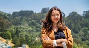
Berkeley Lab research scientist Erica Woodburn is developing a new modeling technique that employs a remote sensing technology to understand the effects of climate change on California’s water supply. (Credit: Marilyn Chung/Berkeley Lab)
Erica Woodburn first fell in love with hydrogeology – the study of the distribution and movement of groundwater – as an undergraduate majoring in geology. “I was fascinated by the idea that we don’t know where and how groundwater moves a lot of the time, and that we don’t know how much of it we have to rely on for the future,” she said.
Today, Woodburn – a research scientist in the Lab’s Earth and Environmental Sciences Area, and one of 10 Early Career Laboratory Directed Research and Development (LDRD) awardees announced in November – is developing a new modeling technique that employs remote sensing technology to understand “the effects of climate change on California’s water supply, including the impact of climate extremes – such as heavy rainfall or snowfall events followed by long periods of drought – that the state has experienced in recent years,” she said.
Some see California’s precious groundwater reserves as a potential buffer against years of drought, but the problem, according to Woodburn, is that you can’t see how much groundwater is actually stored beneath us. “And that’s a huge question in the Central Valley, which supplies much of the state’s water for agricultural, industrial, and municipal uses,” she said. “And without any historical analogues of climate extremes, it’s especially uncertain when trying to project how a new climate will affect our groundwater in the future,” she added.
Woodburn and her research team are using high-performance computing at Berkeley Lab’s National Energy Research Scientific Computing Center (NERSC), a DOE Office of Science User Facility, to model the 3D physical processes of what’s called the Earth’s “critical zone” – the area spanning from deep groundwater up to the lowermost part of the atmosphere.
Their model will be able to quantify how critical-zone dynamics such as groundwater storage changes may affect water availability for vegetation, for example. They can also use their model to simulate how different warming scenarios might affect snow accumulation patterns in the Sierra Nevada mountain range, or affect the environmental flows necessary for endangered or at-risk species.
The team is also modeling a largely unmanaged watershed in Northern California to understand the effects of climate change separate from those of water management. This data will then be coupled with NASA’s GRACE satellite data in an effort to isolate the dynamics and behavior of groundwater storage.
By gaining a better understanding of the hydrologic cycle of this watershed, the researchers hope to “use their results to inform what will happen to groundwater if different water management or climate change mitigation techniques are implemented,” she said.