When geologist Preston Jordan was first hired at Lawrence Berkeley National Laboratory in 1990, his assignment was to study the paleoseismology of the Hayward Fault, which lies to the west of the lab site and is still an active earthquake fault. It was a year after the devastating Loma Prieta earthquake, and funding for such research was abundant. However, within a few years, the funding dried up, and Jordan moved to the Environmental Restoration Program at Berkeley Lab.
He soon became involved in installing groundwater monitoring wells, supervising the drilling for soil samples, constructing geological models and studying groundwater flow. In short, he became Berkeley Lab’s resident expert on the site’s geology—and a highly sought-after one, given the nagging concerns in the area over earthquakes and landslides. “Slope stability is a concern at the Lab, though it’s a concern just as it is anywhere in the Berkeley Hills,” he says. “It’s not a unique concern.”

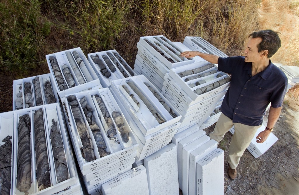
Berkeley Lab geologist Preston Jordan examines core samples taken from a recent experiment at the Lab site, in which hydrogeologists drilled to depths of up to 500 feet. (Photos by Roy Kaltschmidt, Berkeley Lab Public Affairs)
Berkeley Lab occupies about 200 acres in the Berkeley Hills, in an area that covers parts of Blackberry and Strawberry Canyons, with the UC Berkeley campus and residential areas to the west, the Lawrence Hall of Science and dozens of residential homes with stunning views to the north, the UC Berkeley Botanical Garden to the southeast and open space to the northeast and south. With an active earthquake fault nearby and the inclines of the hills, some wonder, are the structures surrounding and at Berkeley Lab safe?
“There’s an active program of slope stability investigation at the Lab,” Jordan says. “The rate of slope stability problems appears to have been decreasing for decades, and ongoing advances in slope stability evaluation and mitigation suggest this trend will continue.”
Geologically speaking, the most serious incident to occur at Berkeley Lab was in 1973, when a landslide transported a portion of a two-story lab and office building, Building 46, about a foot and a half downhill. As it turned out, more precipitation fell from July 1, 1972, through February 1, 1973 than in any equivalent period since the first building was constructed at Berkeley Lab. The slide was subsequently stabilized through a variety of engineering measures. Building 46 was repaired and reoccupied and has experienced no incidents since.

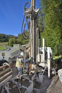
Berkeley Lab hydrogeologists drill for core samples at sites around the Lab to depths of up to 500 feet.
After the next period of intense precipitation, the El Niño winter of 1997-98, the U.S. Geological Survey (USGS) mapped damaging landslides throughout the Bay Area. These maps show such slides in the Berkeley Hills to the north and south of LBNL, but none at Berkeley Lab itself.
“So we have two data points—the 1973 slide and the 1997-98 El Niño winter. Those two data points suggest that stability at the Lab is improving with time due to engineering practices and mitigating the slides that the Lab learns about over time,” he says. Similarly, Berkeley Lab survived the 1989 Loma Prieta earthquake with no major structural damage.
Jordan became interested in geology as an undergraduate at UC Berkeley in the early 1980s. “Scientifically it was an exciting time because there was a whole new theory of how the world worked: it was 10 or 15 years after the shift in paradigm to plate tectonics had occurred,” he says. He later completed a masters degree in geotechnical engineering, also from UC Berkeley.
As an undergraduate he took a course called “The Geology of the Berkeley Hills” from Garniss Curtis. He was impressed to learn about the changes in environment over time. For instance, more than 65 million years ago the entire area was an ocean shelf accumulating sediment now called the Great Valley Group. The shoreline was located near the present day position of the Sierra foothills.
The next oldest rocks belong to the 12 million-year-old Orinda Formation. These consist of sediments deposited on alluvial fans by rivers flowing from a mountain range to the west located where San Francisco Bay is today. Then about 10 million years ago, magma broke through those alluvial fans and deposited volcanic flows, creating the Moraga Formation. The geology of the area has been studied for more than 100 years, and these three formations appear on USGS maps covering the Berkeley Lab site, with the Orinda Formation intervening between the Moraga Formation and Great Valley Group.
Visiting a couple sites at Berkeley Lab, Preston Jordan examines the new hypothesis of the Lab resting atop an ancient caldera and shows evidence to the contrary.
Meanwhile, Curtis retired from UC Berkeley, and in recent years, has put forth an entirely new hypothesis of the geology of the Berkeley Hills. Berkeley Lab, he says, rests on a caldera, or an ancient collapsed volcano, which he likens to “a great big tub of mud with no rigidity.” In this scenario, the caldera occupies the entire area of the Lab beside the Great Valley Group, with no intervening Orinda Formation.
In his decades of studying the area, it was the first Jordan had heard of anyone mentioning a caldera. “It clearly doesn’t match the data we have,” he says. “We’ve drilled hundreds if not thousands of holes across the Lab by this time. Outside of the area of the Great Valley, the majority of holes we’ve drilled don’t encounter volcanic rock at all, they encounter Orinda. I learned about the Orinda Formation from Professor Curtis. I’m baffled by it personally.”
In fact, in the most recent samples taken earlier this year, hydrogeologists drilling to a depth of 500 feet made a new finding at 240 feet: samples rich in clam shells interbedded with the Orinda Formation, indicating it was the location of the shore front, and not an ancient volcano. This was the shoreline of an inland sea to the east that existed between the California Coast Range of the time and the Sierra Nevada. This preserved shoreline has not previously been observed in the Berkeley Hills.
Jordan is no longer working on the Berkeley Lab Environmental Restoration Program, having shifted his focus a few years ago to geological carbon storage, but outside of Berkeley Lab, he continues to remain active in the community. In 2004 he co-founded Albany Strollers and Rollers, a bicycle advocacy and service group. About a year ago he co-founded Carbon-Neutral Albany, which works with the city in attaining its greenhouse gas reduction goal. Additionally, he serves on the city of Albany’s Charter Review Committee and is Supervisor Keith Carson’s appointee to the Alameda County Bicycle and Pedestrian Advocacy Committee.
Asked why he chose to live in Albany, he acknowledges that geology was a consideration: “It’s fairly old ground, it’s probably not going to liquefy and it’s not subject to forest fires or wildland fires. That said, the entire East Bay is going to be severely disrupted by any Hayward Fault earthquake, no matter where you are. We wanted to pick a place where we could have some confidence our house would be somewhat habitable after the event.”
Berkeley Lab is a U.S. Department of Energy (DOE) national laboratory located in Berkeley, California. It conducts unclassified scientific research and is managed by the University of California for the DOE Office of Science. Visit our website at www.lbl.gov.
Additional Information: